From Jackson, MS to Vicksburg, MS, on to Little Rock, AR
 My ride out of Jackson takes me west to Vicksburg, a small town with big ambitions on the Mississippi river. If the levy markers are to be believed this is a town that has seen at least 20 m (90 ft) of flooding in years past. From Vicksburg I head north along windy roads hugging the Mississippi river. After about 3 hours I cross the river and enter Arkansas. My ride out of Jackson takes me west to Vicksburg, a small town with big ambitions on the Mississippi river. If the levy markers are to be believed this is a town that has seen at least 20 m (90 ft) of flooding in years past. From Vicksburg I head north along windy roads hugging the Mississippi river. After about 3 hours I cross the river and enter Arkansas.
Somewhere on the way north I come by 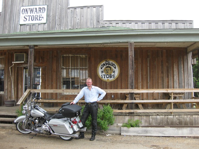 a dilapidated wooden shed that used to be a convenience store. What has me really confused is the sign that says OPEN. Believe it or not, but the shed is a store and it is open. While there, some local residents arrive to do some shopping and they take the opportunity to give me the inside scope – “Mississippi is different” – well, who am I to disagree? a dilapidated wooden shed that used to be a convenience store. What has me really confused is the sign that says OPEN. Believe it or not, but the shed is a store and it is open. While there, some local residents arrive to do some shopping and they take the opportunity to give me the inside scope – “Mississippi is different” – well, who am I to disagree?
Continuing north I arrive in Lake Village. The kind staff at the Visitor Information Center (I always stop at these!) in Lake Village provides me with excellent route suggestions, and the view from the center provides a very nice lookout of a bayou that used to be part of the Mississippi river. Now it is framed by luxury houses and vacation homes. Since the visitor information center provides a wireless network (free!) I take the opportunity to do some further preparations.
Upgrading the bike
After about 4 hours on the bike my bottom is ready to be traded in a for a new one. Well, figure out how to do that! My solution is to get a back-rest that allows me to take some stress of the lower back and shift the pressure points.
With the wireless provided at the Visitor Center I get connected with Landers Harley-Davidson, just north of Little Rock, AR, about three hours out from where I am. They have the adjustable backrest I have been looking for in stock and I now know where to head. As I get there I also ask Landers HD to do an oil change since it will be several thousand of miles before I get back to Seattle.
Little Rock, AR to Russellville, AR
From Little Rock I continue north west to Russellville, AR. With the new back rest mounted I feel like I can go on forever! Picking up on the trend from the first night, I stay at the local Best Western.
As I settle in for the night I realize that my hands are burning. Since I wanted to get started on a nice tan I rode in a linen shirt (the shirt is equivalent to ~SPF 15) however I didn’t protect my hands and I will now pay the price. This means wearing gloves for the next few days. Well, well…
Btw, I am one of the guys who wears ATGATT (“all the gear, all the time”) when riding a motorcycle, but as I have to confess, when I go on a two weeks vacation in hot weather it is just too much to ask for. I still wear good boots, leather pants and a helmet. |
| Tools of the trade
Planning a trip across this vast continent requires a bit of preparation. Having the right tools at hand make a huge difference. Here are the top resources I use:
Streets & Trips 2009
This software installs on the computer (a Sony VAIO laptop in my case) and allows me to plan routes, look up hotels (and telephone numbers), calculate riding times and stops, and much more. It is definitely the tool I have come to depend on. Since it doesn’t require an internet connection I can always access it. Caveat,: the laptop still uses battery even if it is not online 🙂
Ride Planner @ Harley Davidson
Being able to outline your routes doesn’t mean much if you don’t know where the amazing routes are to be found. I discovered this nifty tool at www.harley-davidson.com >> Experience >> Ride Planner >> Launch.
Ride Planner is an online tool that allows you to explore the US and find amazing motorcycle routes. There is a base set of “roads” provided by America’s Byway and then there is a wealth of rider submitted “roads”.
While I love the tool and what it allows me to find, this is one example where the online experience doesn’t compete with having the tool installed locally.
The best of both worlds would be to have Streets & Trips locally and download interesting routes from Ride Planner. In fact, you can (almost) do this through a feature called GPS Synchronization in Ride Planner. However Ride Planner uses Garmin’s GPX format which Streets & Trips doesn’t like. You can use conversion tools but then it gets cumbersome. Definitely an opportunity for improvement!
And here is a secret shared for you: you don’t have to ride a Harley to use the Ride Planner! Please don’t tell anyone I told you!
Tethering
Tethering means you use your cell phone’s data plan and get your computer online by connecting it to the cell phone via a USB cable. It is a feature of Windows Mobile and you can use it right away!
Ehh, not true! I have AT&T as my carrier and AT&T requires an extended subscription plan to allow Tethering. I got it for $30 per month (on top of my voice + data plan) and will only use it for one month (but I need to remember to cancel the service in time).
Visualize this – I am jumping up and down and shouting HURRAY!
I am super happy with Tethering! I can now get connected anytime anywhere (well, allow me to rejoice even if the coverage isn’t universal). Even while hunkering down under a small bush in the middle of nowhere to escape blistering sun burns I have been able to get connected. The world is changing! |
|
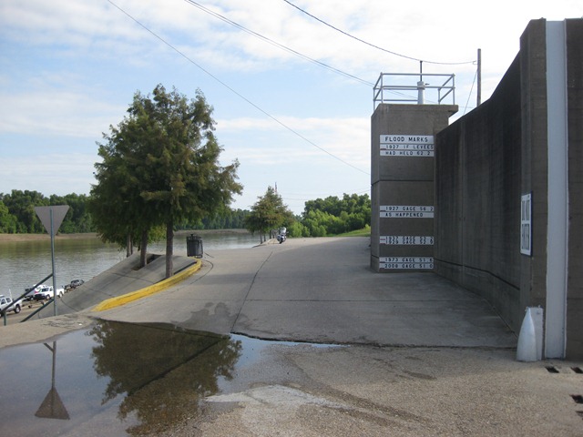 My ride out of Jackson takes me west to Vicksburg, a small town with big ambitions on the Mississippi river. If the levy markers are to be believed this is a town that has seen at least 20 m (90 ft) of flooding in years past. From Vicksburg I head north along windy roads hugging the Mississippi river. After about 3 hours I cross the river and enter Arkansas.
